Access, explore, and share GNSS data, metadata, and products supporting Solid Earth Science across Europe.
What is EPOS
The European Plate Observing System (EPOS) is a pan-European distributed research infrastructure that integrates data, tools, and services for studying the solid Earth. The backbone of EPOS are Thematic Core Services (TCS), which cover the different domains of the solid Earth science.
The European Research Infrastructure Consortium (ERIC) is the dedicated European legal form for running Research Infrastructures on a non-economic basis. EPOS was officially granted ERIC status by the European Commission on October 30, 2018, securing legal personality and operational flexibility across the EU.
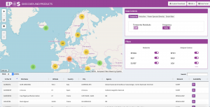
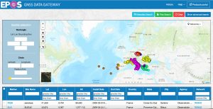
The mission of the GNSS Thematic Core Service (TCS) is to provide, through EPOS, access to GNSS data, metadata, products, and software supporting research in the Solid Earth Sciences.
Facilitate access to validated GNSS data, metadata, and related products
Coordinate the archiving of GNSS data, metadata, and derived products
Promote best practices for GNSS station operation, quality control, and data management
Maintain and distribute open-source software for GNSS data discovery
Develop and maintain GNSS-derived data products
These efforts are realised in close collaboration with EUREF community (https://www.euref.eu)
Connecting Europe through GNSS Science
Open Source Platform — GLASS
The EPOS GNSS Thematic Core Service has developed an open-source platform called GLASS, designed to store and disseminate GNSS data, metadataand products from stations operating across Europe. Read more on the link below:
This website uses cookies to improve your experience. We'll assume you're ok with this, but you can opt-out if you wish.AcceptRead More
Privacy & Cookies Policy
Privacy Overview
This website uses cookies to improve your experience while you navigate through the website. Out of these cookies, the cookies that are categorized as necessary are stored on your browser as they are essential for the working of basic functionalities of the website. We also use third-party cookies that help us analyze and understand how you use this website. These cookies will be stored in your browser only with your consent. You also have the option to opt-out of these cookies. But opting out of some of these cookies may have an effect on your browsing experience.
Necessary cookies are absolutely essential for the website to function properly. This category only includes cookies that ensures basic functionalities and security features of the website. These cookies do not store any personal information.
Any cookies that may not be particularly necessary for the website to function and is used specifically to collect user personal data via analytics, ads, other embedded contents are termed as non-necessary cookies. It is mandatory to procure user consent prior to running these cookies on your website.